
Hi there!
So Tahquamenon Falls State Park is probably the most popular state park in the Upper Peninsula of Michigan.
There are 2 main parts to Tahquamenon Falls:
- Upper Falls
- Lower Falls
If you are only making time for just ONE portion of the falls, and you are looking for the best views to SEE the waterfalls, then I like Upper Falls for the views!
If you want to EXPERIENCE the waterfalls, then the Lower Falls are better – you can get up close and personal, like wade in the river.
I went to Tahquamenon Falls State Park and also stayed overnight!
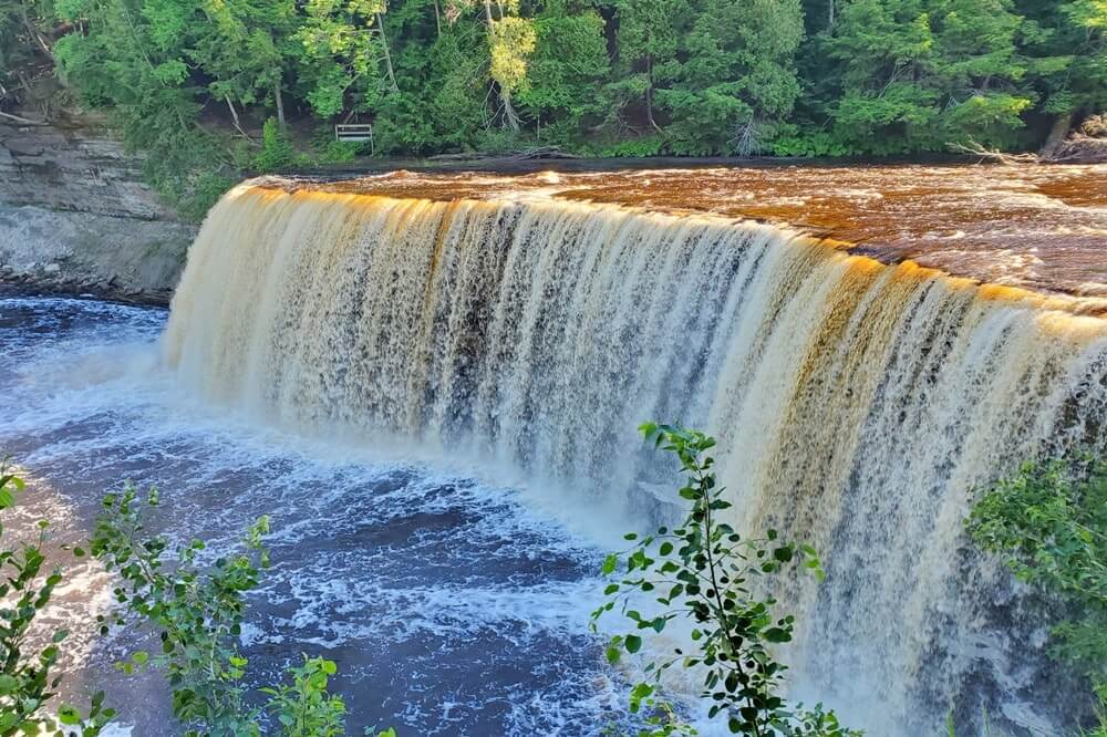
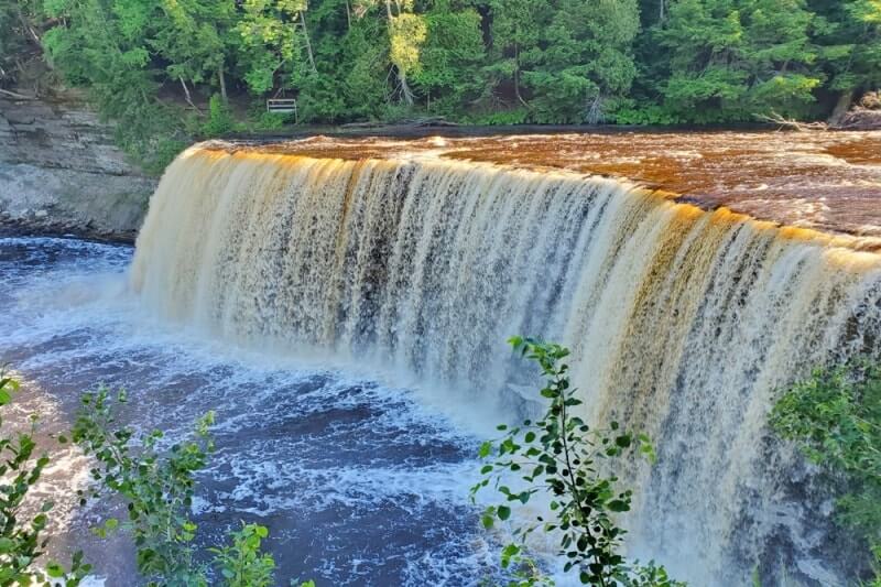
See below for a bit about what it’s like to see the Tahquamenon Falls UPPER Falls!

📌 Save this post for later! Save on Pinterest! 👈📌
There are partner websites included in this post.
🌞

With the Upper Falls portion of the state park, there is no direct Tahquamenon River access, but you can get pretty close and also get some great views from the overlooks!


Unlike some of the roadside waterfalls in Michigan in which you can basically drive straight up to the waterfalls, it will take a little bit of walking to get to the Upper Falls. It’s a short walk on a paved trail, until the stairs.


Hiking from Upper Falls to Lower Falls
Or Lower Falls to Upper Falls
You can drive to both the Upper Falls and Lower Falls.
But if you want to do a solid day hike when you are at Tahquamenon Falls State Park, then you can hike the River Trail.
This is a hiking trail mostly through a forest that connects the Upper Falls and Lower Falls. This would be around 8 miles round trip. This trail distance doesn’t include the walking to/from the parking lot, along with the walking you will do to get to the various waterfall overlooks. So you can expect to walk maybe 9-10 miles.
There is typically a hiker shuttle so you wouldn’t have to hike it both ways, but this is not operating in 2020 because of health safety reasons.
Starting from Upper Falls

If you want to hike from Upper Falls to Lower Falls, you will go towards the gorge viewing area of Upper Falls. You will see the trail right in front of the stairs that goes down to the gorge.
Starting from Lower Falls

If you want to hike from Lower Falls to Upper Falls, you will hike to the main viewing overlook of Lower Falls. Then you will see signs that lead you to the River Trail.
Backpacking the North Country Trail

The North Country Trail is a national scenic trail that extends for 4,600 miles across many states from the midwest to the east coast. It also goes through Tahquamenon Falls State Park, and by hiking the River Trail, you will actually be on the NCT!
Camping near Upper Tahquamenon Falls

There are modern campgrounds in Tahquamenon Falls State Park, somewhat near the waterfalls. For the campground closest to the waterfalls, that would be the Lower Falls campground. This can be for both tent camping and RV camping.
There are more campgrounds that are part of the state park away from the waterfalls. This is near the mouth of the Tahquamenon River on Whitefish Bay (that is a Lake Superior bay).
🌳
PHOTOS of the trail to the Upper Falls overlook
…and getting there
The Upper Falls and Lower Falls are located in separate areas of the park, so you’ll need to drive to each of them separately. (If you’re not hiking.)
If you visit the Lower Falls first, you’ll see directions as you leave the Upper Falls portion of the state park.


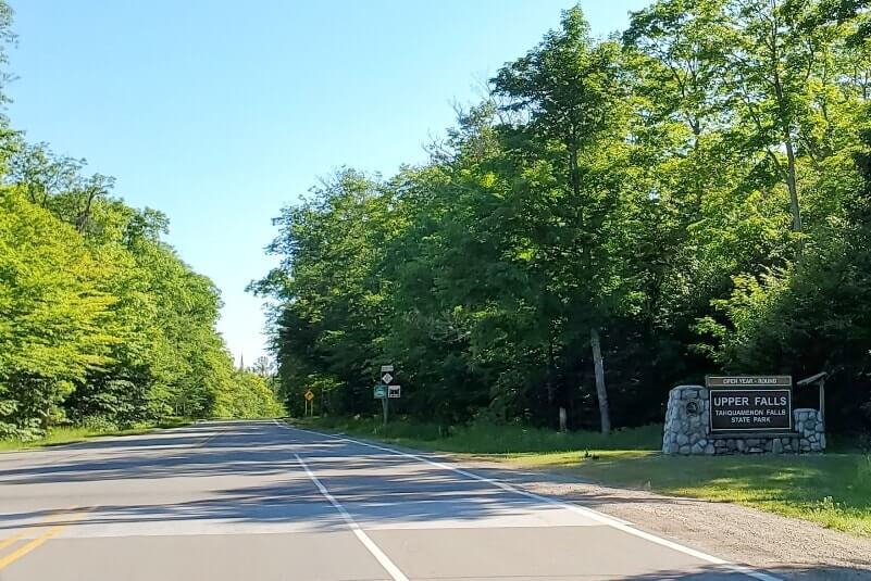
Otherwise, Tahquamenon Upper Falls is located on google maps. And that will get you to the Upper Falls trailhead parking lot.


Cost of visiting Tahquamenon Falls

Both the Upper Falls and Lower Falls are a part of a Michigan State Park, and it requires the Michigan recreation passport.
If you are a Michigan resident, hopefully you already have the annual recreation passport, in which case it basically makes this a FREE waterfall spot!
If you don’t have the recreation passport, or you’re from out of state, then you’ll pay the fee upon entry.

In 2020, for Michigan residents the annual pass is around $17 when purchased at a state park. For out-of-state residents, the annual pass is around $34 while the daily pass is around $9. See current fees here.
Upper Falls Trail
There are 2 main overlooks to see the Upper Falls that you can visit.
There is a sign where they split off, so they are basically 2 different trails. There is the “brink” viewing area, and the “gorge” viewing area.
If you give yourself 1 hour, you can comfortably be in and out of the Upper Falls part of the state park without feeling rushed. This will give you time to go to at least 1 of the main overlooks, maybe 2.
BUT.
When I was at the Upper Tahquamenon Falls in summer 2020 (July), the “brink” viewing area overlook was open, but the “gorge” viewing area overlook was closed.
At the start of the trail, there is a trail map. Check this when you arrive. It will tell you if the gorge overlook is still closed. You may still be interested in taking that trail just a little, as there are a couple of overlooks that will provide different angles of views of the Upper Falls from a distance.


The Upper Falls trail map to check before you start. You can see this map says the gorge area of the Upper Tahquamenon Falls is CLOSED.


As you are on the trail and make your way to the stairs to the main overlook, you’ll come across some overlooks for a distant view of Upper Falls.


And then, maybe after around a 10 minute walk from the parking lot, you’ll come to the stairs that will take you to the brink viewing area.


ENJOY SEEING TAHQUAMENON UPPER FALLS!!


Upper Falls gorge overlook
Again, when I went in July 2020, the Tahquamenon Upper Falls gorge viewing area was closed.


But when the gorge area opens back up, here is a bit of what you can see! (I was also here a few years ago.)


And that’s a bit about a short visit to the Upper Falls of the Tahquamenon River!
See more ideas for planning your time in Tahquamenon Falls State Park!
More ideas for the U.P.
- Things to do on the drive from Munising to Marquette
- Pictured Rocks trail with waterfalls and colorful beach
- Pictured Rocks dune climb
- The bubbling Big Spring
- Hidden gem in the Keweenaw Peninsula
- Lower Peninsula Mackinac Bridge view on your way up to the U.P.
Explore Lake Michigan too! (Time listed from Tahquamenon Falls)
- Leelanau Peninsula (lighthouse visit – 4.5 hours)
- Sleeping Bear Dunes (U.S. national lakeshore visit – 4.5 hours)
- Muskegon State Park (lighthouse, beach, sand dunes! – 5.5 hours)
HAPPY SEEING THE UPPER TAHQUAMENON FALLS!
There are partner websites included in this post. I may earn a commission.