
Hi there!
You get to the Log Slide overlook by going to the Grand Maris side of Pictured Rocks.
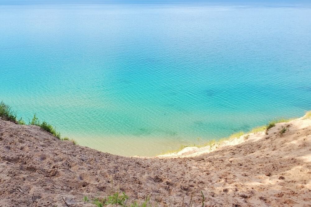
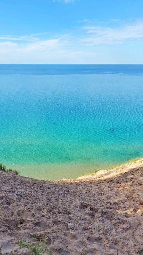
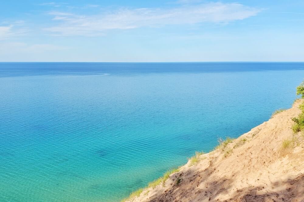
The Log Slide overlook is 175 feet high, according to the National Park Service.
You will be on top of the Grand Sable Dunes of Lake Superior!
The log slide overlook is one of the great scenic overlooks located in Pictured Rocks National Lakeshore.

There is a parking lot that is near the log slide overlook, so this can be a relatively quick stop.
And if you are looking for hikes in Pictured Rocks, there are also longer hiking trails that can include a stop at the Log Slide Overlook… that can include Lake Superior views as you hike!
Log Slide dune climb
If you are interested in climbing sand dunes, then this is also a spot that you can do so!
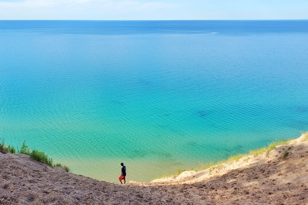
You can go all the way to the bottom to reach Lake Superior, and then climb back up!


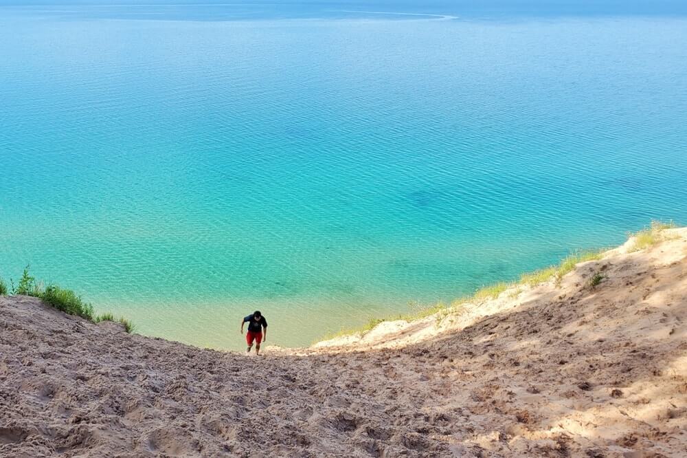
It will be strenuous!
Sand is not easy to walk in, and it’s even more difficult when you’re going up a hill in sand! Be sure you are carrying water and snacks!
The warning from the National Park Service:
Going down only takes a few seconds – coming up may take an hour or more.
The Log Slide is very steep and over 500 feet to the bottom.
If you are not in good physical condition, do not go down the log slide.
Sand and rocks may roll down on you from people climbing above.
Overhangs are hidden at the bottom.
Rescue is difficult and may be delayed due to the distance from the local ambulance service or Lake Superior weather conditions.
The National Park Service has conducted several visitor rescues here in recent years – don’t become a statistic!
The changing log slide

According to the National Park Service:
The area around Log Slide has changed significantly in the past 100 years.
As people walk and slide down the face of the dune, sand is destabilized.
Grain by grain, prevailing winds pick up the sand and transport it to the top, creating the dune at the Log Slide.
As people travel up and down the dune, more sand is dislodged to be blown back up on top, causing the dune to grow year by year.

Cost to visit Pictured Rocks National Lakeshore
According to the National Park Service:
To access Pictured Rocks National Lakeshore, you must possess and display:
Pictured Rocks 7-Day or Annual Entrance Pass
OR
America the Beautiful Pass (Annual, Military, Fourth Grade, Senior, or Volunteer).
If you already have an America the Beautiful Pass, you do not need to buy a separate Pictured Rocks Entrance Pass!
The Pictured Rocks entry fee will cover all overlooks in Pictured Rocks National Lakeshore.
The cost to visit Pictured Rocks in 2023 is $20 per car. This will get you a 7-day Pictured Rocks national park pass. (There is no one-day Pictured Rocks pass.)
Confirm current Pictured Rocks fees.
You can buy a Pictured Rocks national park pass at a Pictured Rocks visitor center when you arrive, or you can buy it online at recreation.gov before you go.
If you will also be visiting other national parks that have entry fees, then you may want to look into getting an annual national park pass aka the America the Beautiful pass!
This annual national park pass will also be accepted at Sleeping Bear Dunes National Lakeshore.
Other popular national parks “near” Michigan include Mammoth Cave National Park in Kentucky and Great Smoky Mountains National Park in Tennessee and North Carolina, but these parks do not have a national park entry fee.
If you have several more weeks to spare in the summer or fall, you can make use of the America the Beautiful national park pass by driving out to Yellowstone National Park!
You can go to national parks in Wyoming and national parks in South Dakota, and you could even add on a national park in North Dakota and/or a national park site in Idaho! See how I did the drive from Chicago to Yellowstone.
If you are a senior, there is also an annual national park pass for seniors that will be worth it even if you only visit Pictured Rocks National Lakeshore! It’s $20! See current fees under America the Beautiful passes.
More below about how to see the Log Slide dunes and Lake Superior!
🌳
The quick way to see the Log Slide Overlook


Even if you don’t do the dune climb, seeing the views from the overlook can be worth it, and it can be a relatively quick stop.
You probably won’t need more than 15-20 minutes.
But of course, it’s possible to stay for longer if you want to take in the views and walk around a bit!
So Pictured Rocks National Lakeshore has the town of Grand Marais on one side to the east (side of the big sand dunes) and Munising on the other side to the west (side of the famous cliffs).
The Log Slide Overlook is on the Grand Marais side.
Your destination for google maps can be the Log Slide Overlook or Log Slide parking area.
It will be best if you have offline google maps downloaded before your UP trip, as data is spotty in the Upper Peninsula. GPS generally works.
When driving from Grand Marais (which is also the direction you’ll be coming from if you’re coming from the popular Tahquamenon Falls State Park), you’ll see signs for the Log Slide Overlook shortly after you enter the Pictured Rocks National Lakeshore park.
Then once you’ve arrived to the parking lot, you can follow the sign to the overlook. The walk to the overlook will take about 5 minutes.
You will pass by historic logging equipment along the way. It’s posted that “big wheels were invented in downstate Michigan to extend the logging season year-round.”


Pictured Rocks is bear country. A fed bear is a dead bear: It’s said that once a bear connects humans to food, it becomes dangerous to humans. So if a bear shows tendencies that it has learned to look to humans for food, it may be killed for human safety. This is why it’s said that it’s important to store food properly, and to not feed them if you do see one.


You’ve made it!


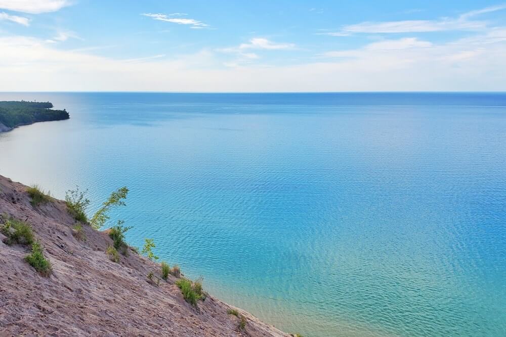

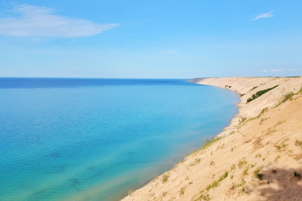
It’s is possible to walk alongside the dunes here in either direction, but edges can be unstable so you’ll want to be careful.


Hiking to the Log Slide Overlook
Now, if you’re looking for hiking trails in Pictured Rocks, then you can park a bit further away, and there are a couple of out-and-back hiking options for you!
Hurricane River to Log Slide (and back)
Around 7.5 miles round trip

This is the among the best day hike options when you want to include the log slide overlook.
This will actually be from the Hurricane River to Au Sable Point Lighthouse to Log Slide Overlook, and back.

The lighthouse is only accessible by foot. There is no parking lot directly near the lighthouse.
There are many chances to see Lake Superior along the way if you hike from Hurricane River to the Log Slide.
There is a drive-in rustic campground at Hurricane River.
Twelvemile Beach to Log Slide (and back)
Around 12.5 miles round trip

If you want to make it a longer day hike, then you can also consider hiking from Twelvemile Beach to the Log Slide Overlook and back.
This basically makes it a hike that is Twelvemile Beach to Hurricane River to the Log Slide.
The trail from Twelvemile Beach to Hurricane River is mostly through a forest, but you might like ending your day back at Twelvemile Beach where there’s a nice sandy beach! Lake Superior is cold so it’s more for the views, although there are people who do swim.
There is also a drive-in rustic campground at Twelvemile Beach. I stayed at all 3 drive-in campgrounds in Pictured Rocks, and this was my favorite campground for the views! You can see Lake Superior from most, if not all, campsites here!
One-way hikes
If you have both hikers and non-hikers in your group, another option is for the hikers to be dropped off and hike one way and get a pick-up from the non-hikers elsewhere in the park! Or, if you’re camping at one of the drive-in campgrounds, hikers can get a drop-off and hike directly to the campground.
Some one-way hikes that will pass by the Log Slide Overlook that also have parking lots as drop-off or pick-up points can be:
- Start from the Grand Sable Visitor Center and hike to Log Slide Overlook (around 6 miles)
- Start from Twelvemile Beach (around 6.5 miles) or Hurricane River (around 4 miles) and hike to Log Slide Overlook (or hike the opposite direction)
One-way hiking distances:
- Twelvemile Beach to Hurricane River: 2.5 miles
- Hurricane River to Au Sable Lighthouse: 1.7 miles
- Au Sable Lighthouse to Log Slide Overlook: 2 miles
- Grand Sable Visitor Center to Log Slide Overlook: 5.8 miles
Backpacking the North Country Trail

The North Country Trail is a national scenic trail that extends for 4,600 miles across many states from the midwest to the east coast. It also goes through Pictured Rocks for around 40 miles, and there are backcountry campsites along the way.
If you’re backpacking the North Country Trail through Pictured Rocks, the NCT goes near the Log Slide Overlook.
If you choose to hike to the log slide overlook as a day hike (from the visitor center, Hurricane River, or Twelvemile Beach), you will be hiking on the North Country Trail too.
And that’s a bit about getting to the Log Slide!
If you’re interested in the Grand Sable Dunes, you may also be interested in these Pictured Rocks activties:
- Sable Falls
- Miners Falls
- Chapel Rock
- Twelvemile Beach campground
- Munising Falls
- Little Beaver Lake campground
See more of Pictured Rocks:
- Lake Superior beaches in Pictured Rocks
- Waterfalls in Pictured Rocks
- More things to do in Pictured Rocks National Lakeshore
See more of the UP:
- Kitch-iti-kipi
- Alger Falls
- Driving from Grand Marais to Pictured Rocks
- Driving from Pictured Rocks to Marquette
- Stops to make on a circle the UP road trip
Plus for more sand dunes in Michigan, be sure to consider going to Sleeping Bear Dunes National Lakeshore!
HAPPY LOG SLIDE DUNES VISIT IN PICTURED ROCKS!

There are partner websites included in this post. I may earn a commission.