
Hi there!
Below is basically a Grand Teton National Park planning map.
Use it to plan your epic Wyoming national parks road trip!
See below for the clickable interactive version of the Grand Teton National Park map! Most icons have pictures, and some have additional info too! If you are on your phone, also see tips for using the map on mobile below the interactive map!
Be sure to play around with the map!
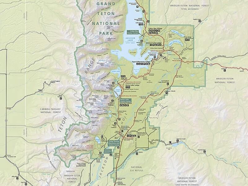
Grand Teton National Park map (official National Park Service map)
If you are looking for the official Grand Teton National Park map from the National Park Service: Grand Teton National Park map
There is also a separate interactive Grand Teton National Park hiking map that is also interactive.
Be sure to also get a map at the national park entry station that you arrive at!
👆 You can find an interactive Grand Teton National Park map on the National Park Service website. See below for an interactive map with pictures and locations of scenic spots!
You can also download the National Park Service app and look for Grand Teton National Park.
If you are looking for a more detailed Grand Teton National Park campground map, the easiest way might be by using the official Grand Teton National Park camping reservation website. Search for any date, and even if there’s no availability, you can click on each of the loops to view the campground map.
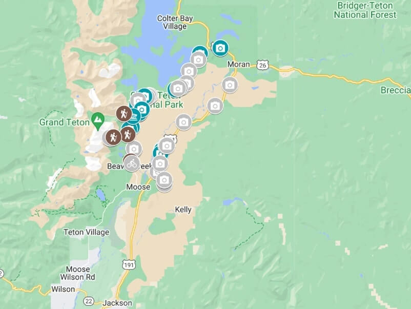
Grand Teton National Park map (interactive google map)
Click the little icon in the top left corner of the map below to see the list of what you’ll find on this map.
On the map, click on an icon to know what’s there!
Colored icons mean that there’s a link with more information about that spot.
Read about it: Things to do in Grand Teton National Park
👆 How to start using this map: Click the top left icon! Or just zoom in to start looking and clicking around!
This map may not work very well on this page on mobile, sorry!
In that case, send a link of this page to yourself and try on desktop!
Or…
Tips for using this google map of Grand Teton National Park on mobile!
If you are on your phone, you can also take a look at this Grand Teton National Park map. (It is the same map as above but it might be easier for use on your phone.)
For this map, in short, in addition to clicking the icons that you see on the map, also click on the names that come up when you click on an icon!
Most icons have pictures and/or info to go along with it so if you are not seeing it, then click around!
Longer version…
If you do look at the map directly on google, start off by clicking the text at the bottom of the screen (the text that says “grand teton national park map”) to see the different categories.
Then you can start clicking around on this list.
Or, you can also just start clicking around on the map.
When you click on an icon on the map, you will see the name of the spot come up at the bottom of the screen.
Click on that name.
Then, you will see a picture of that spot (in most cases!) and also possibly more info!
Phones may have different displays but basically click around on both icons and text!
What is on the Grand Teton National Park map?
- Things to do in Grand Teton National Park
- Grand Teton National Park scenic roads
- 42-mile Grand Teton Scenic Loop Drive stops
- Teton Park Road stops (aka western side of Grand Teton scenic loop drive)
- Grand Teton National Park hikes
- Grand Teton National Park lakes
- In short… How to see the Teton Range!
Possibly more for your Wyoming road trip and beyond!
- Things to do in Yellowstone National Park
- Devils Tower to Grand Teton National Park
- Mount Rushmore to Grand Teton National Park
- Best places to visit in Wyoming
- Things to do in Devils Tower National Monument (Wyoming)
- Snowy Range Scenic Byway in Medicine Bow National Forest (Wyoming)
- National forest cabins in Wyoming
- Best places to visit in South Dakota
- Things to do in Craters of the Moon National Monument (Idaho)
HAPPY GRAND TETON NATIONAL PARK TRAVEL PLANNING!