
Hi there!
So you want to go to see some stunning views in Wyoming as part of your Wyoming road trip!
What are some of the best hikes in Wyoming that will give you amazing views of mountain lakes?!
I went hiking in Wyoming in late September and early October during my 7-day Wyoming road trip! These are the hikes that I did!

The locations of the best Wyoming hikes are also some of the best places to visit in Wyoming!

📌 Save this post for later! Save on Pinterest! 👈📌
1. Lost Twin Lakes Trail (Bighorn National Forest)

The Lost Twin Lakes Trail is in the Cloud Peak Wilderness area of Bighorn National Forest.
There are 2 lost twin lakes. Hiking to the first Lost Twin Lake is around a 13 mile round trip hike.
You may want to give yourself around 6 hours to complete this Bighorn National Forest hike.
The Lost Twin Lakes Trail start from the West Tensleep trailhead (map).
If you are looking to go backpacking in the Wyoming mountains, the Mistymoon Lake Trail to Cloud Peak seems to be one to consider. You can also start this from the West Tensleep trailhead.
You can find a Wyoming national forest cabin in Bighorn National Forest.
2. Jade Lakes Trail (Shoshone National Forest)

The Jade Lakes Trail is in Shoshone National Forest.
The Jade Lakes are near the Teton Wilderness area that’s a part of Bridger-Teton National Forest.
You’ll be hiking on a part of the Continental Divide Trail for a short portion.
There are 2 Jade Lakes, the Upper Jade Lake and Lower Jade Lake. Hiking to both Jade Lakes is around a 5.5 mile hike round trip.
You may want to give yourself around 3 hours to complete this Shoshone National Forest hike.
The Jade Lakes Trail starts from the Brooks Lake trailhead near the Brooks Lake campground (map). If the gate is closed to the trail, it’s only closed for the horses, so look for the walking path.

3. Hike to Delta Lake (Grand Teton National Park)
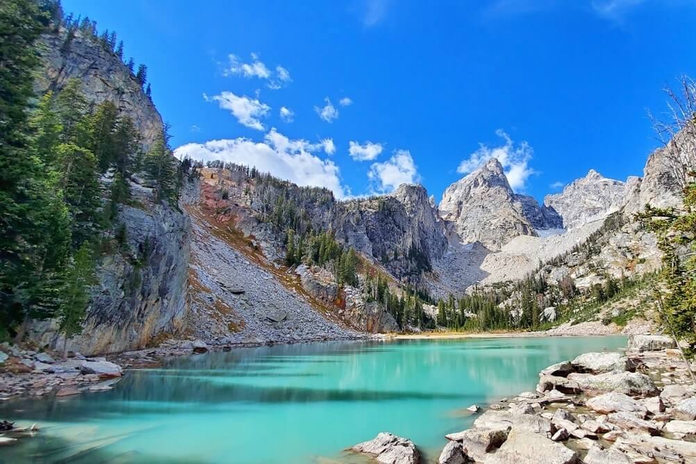
Delta Lake is in Grand Teton National Park.
Hiking to Delta Lake is around an 8.2 mile round trip hike.
The last part of the trail you will be walking across large rocks (boulders) which can slow you down. There is also a very steep hill shortly before you reach Delta Lake.
You may want to give yourself around 5 hours to complete this Grand Teton National Park hike.
The hike to Delta Lake starts from the Lupine Meadows trailhead (map). You will drive part of the Grand Teton scenic loop drive to get there.
This trail starts off on an official national park hiking trail (the Surprise Amphitheater Trail), and then you’ll look for the hidden trail to Delta Lake as it turns off onto an unmarked and unofficial trail!
4. Hike to Surprise Lake and Amphitheater Lake (Grand Teton National Park)


You will pass by Surprise Lake as you hike to Amphitheater Lake, and these lakes are in Grand Teton National Park. This is an official national park hiking trail.
Hiking to the further Amphitheater Lake is around a 10.1 mile hike round trip.
You may want to give yourself around 6.5 hours to complete this Grand Teton National Park hike.
The hike to Surprise Lake and Amphitheater Lake starts from the Lupine Meadows trailhead (map), and it starts off on the same trail as the Delta Lake hike.
If you are up for a longer hike, you can combine this hike with the Delta Lake hike. The Surprise, Amphitheater, Delta hike would be around an 11.5 mile hike round trip, and you may want to give yourself around 7.5 hours to complete this hike.
See more about planning your trip to Wyoming:
- How to get to the hidden Delta Lake trail
- How to spend one day in Grand Teton National Park with hiking
- Driving through Grand Teton National Park
- Driving from Grand Teton to Yellowstone
- How to spend one day in Yellowstone National Park
5. Medicine Bow Peak Trail (Medicine Bow National Forest)

The Medicine Bow Peak Trail is in the Snowy Range area of Medicine Bow National Forest.
The Medicine Bow Peak is listed as 12,000+ feet, and there are a few different ways you can get there. One way to get to Medicine Bow Peak is to start from Lewis Lake. Along the way, as you climb higher, you’ll see more lakes from above.
Hiking to Medicine Bow Peak from Lewis Lake is around a 3.2 mile round trip hike. As you get near the peak, you will be walking across big rocks and boulders which again can slow you down.
You may want to give yourself around 3 hours to complete this Medicine Bow National Forest hike.
If you’ll be starting the hike to Medicine Bow Peak from Lewis Lake, you’ll look for the Lewis Lake trailhead and signs for the Sugarloaf Mountain area (map).

You’ll be driving along the Snowy Range Scenic Byway to get to the Medicine Bow Peak Trail.
If you’ll be driving from the west (Saratoga WY side), you’ll be driving the best part of the Snowy Range Road to get to the trailhead. If you’ll be driving from the east (Centennial WY side), be sure that you drive to at least Lake Marie (map) so you’ll also pass by the best of the Snowy Range drive!
You can find a Wyoming national forest cabin in Medicine Bow National Forest.
⛰
MAP: Hiking in Wyoming road trip route

Explore the map.
You can make it somewhat of a loop around Wyoming as you drive around the state to go hiking in Wyoming national forests and a Wyoming national park.
Wyoming and Idaho road trip

Explore the map.
If you have extra days and are interested in volcanoes and lava fields, then you can leave Wyoming out of the west to go to Craters of the Moon National Monument in Idaho, and then loop back around to Wyoming! There are some cave hikes in Craters of the Moon that you can do!
Hiking the Wyoming mountains: These Wyoming hikes are at high altitude!
The generally accepted elevation for what is considered high altitude is around 8,000 feet. All of the Wyoming hikes on this list start at above 8,000 feet.
You may not feel ill effects of altitude sickness from being at a high altitude, but it is possible. What is more likely is that you may find yourself getting tired or out of breath more quickly.
For bigger hikes that you plan on doing, you may consider staying at high altitude the night before your hike to help yourself better acclimate to the altitude.
Great FREE apps for hiking in Wyoming
For all of these apps, you will need your GPS locator on your phone to be turned ON.
You’ll be hiking in the Wyoming mountains, which means that you are likely to get no service for much of your hike.
Even if you get no data service, your GPS will generally work. As a side note, when you are hiking, consider putting your phone in airplane mode. This way it’s not wasting extra energy (battery) searching for data/phone service as you are hiking.
1. Google maps OFFLINE
For driving directions to the hikes on this list, google maps will work… as long as you have downloaded offline maps ahead of time!
There’s a good chance you will not have data as you are driving to some of these places, so you will want to have offline access to maps.
Offline google maps is free.
You will generally still have GPS, so offline google maps will work well to navigate to the trailhead.
2. Mapsme: Wyoming map
I referred to the mapsme app during all of the Wyoming hikes on this list. This app is also free.
You will just want to be sure to specifically also download the Wyoming map before you leave for your trip.
The mapsme app has a lot of hiking trails mapped out, and it had all of the hikes on this list. I loved the mapsme app for being able to refer to it to have confidence that I was on the right trail. Some of the hikes don’t have well-marked trail signs.
The GPS may not always to perfectly accurate, but it can still be quite helpful.
I HIGHLY recommend this app for hiking in Wyoming!
3. What is my elevation
This is actually a website, not an app.
And this is not an essential Wyoming hiking app, but it’s more for fun.
Open up this website whatismyelevation.com on your phone, and don’t close out of the tab. (Again, it will only work if you have GPS enabled.)
Then, even if you’re offline, you can just go to the tab with this website open and it will tell you your elevation! This can be great to look at while driving and hiking to know what elevation you’re at. It may not be perfect, but it will give you a general idea!
And that’s a bit about making it a hiking trip to Wyoming!
See more about planning your trip to Wyoming:
Also see about making it a hiking trip to the Dakotas!
- Best places to visit in South Dakota
- South Dakota national park hiking trip
- South Dakota state park hiking trip
- North Dakota national park hiking trip
HAPPY HIKING IN THE WYOMING MOUNTAINS!
