
Hi there!
So, standing atop Clingmans Dome is one of the most things to do in Great Smoky Mountains National Park.
It is also considered to be among the best views to be seen in the Smoky Mountains.
Clingmans Dome is the highest point in the Smoky Mountains, and it’s also said to be the highest point in Tennessee.
It requires a hike up a relatively short but steep paved trail to get to the top of Clingmans Dome observation tower.
I did the hike to Clingmans Dome in September. What the weather will be like from year to year can vary (which means the colors can vary!), but this is what it was like for me!


But the thing about going to Clingmans Dome is… well, it can be “SMOKY” in the Smoky Mountains. Although this generally refers more to the haze in the Smoky Mountains, you can also have it referring to the fog and clouds…
This means that you can also end up going to Clingmans Dome and…
HELLO!!


Great views…
There’s nothing to see!!!
Or… you can go on a GREAT weather day, and…
HELLO!!


Actually GREAT views!!
If there’s good weather, you can also get some great views of the Smoky Mountains before you even start the trail too, at the end of Clingmans Dome Road from the Clingmans Dome parking lot.


I actually made several “attempts” to see the views from Clingmans Dome. I’ll get into these attempts below in a bit, but first…
Clingmans Dome Trail basics

Official info for the Clingmans Dome Trail:
- Clingmans Dome is listed as 6,643 feet (this is the spot before you take the final path up to the top of the tower)
- It’s a half mile trail from the parking lot to the Clingmans Dome observation tower
- You’ll be hiking up 330 ft on the trail
If you’ve packed hiking poles for your Smoky Mountains trip, then bring them for this hike!

Great Smoky Mountains National Park is located in both Tennessee and North Carolina. And the actual “summit” or “dome” area of Clingmans Dome is also said to be located in both states! The path to the observation tower starts around the highest point in the Smoky Mountains.

There is a Great Smoky Mountains National Park visitor center at the start of the trail to Clingmans Dome.
Clingmans Dome weather
You’ll want to keep in mind that Clingmans Dome is at a higher elevation. This means that temperatures may be cooler than you expect!
When I went in late September late morning (11am), the temperature at the Clingmans Dome parking area was in the mid-40s and I felt like I was preparing for a winter hike when I got out of the car!

But it also does warm up (relatively speaking) so layers of clothing are key! Depending on the time of year you’re hiking, you may want to bring an extra long sleeve shirt, light jacket, and/or sweatshirt.
Clingmans Dome Road to the parking lot is closed in winter and early spring


The road to the Clingmans Dome parking area (Clingmans Dome Road) is closed in December, January, February, and March. This means that you can’t drive up there during this time, and you can’t start the hike to Clingmans Dome from here.
If you’re visiting the Smoky Mountains in winter or early spring, it would be a good idea to check for any special winter alerts provided by the National Park Service before you go to. There is also a twitter account you can check for road closures.
In 2020, Clingmans Dome Road opened on March 30. As your travel date gets closer, you can also check the official updated road information here.
Also, if you are doing your Smoky Mountains vacation planning early (like during the winter or early spring months when the road is closed), google maps might tell you that driving directions aren’t available if you’re mapping out Clingmans Dome.
It seems like this is because they are accounting for the current seasonal road conditions.
So just to give you an idea, you can instead map out to the start of Clingmans Dome Road, which would be the turnoff point from Newfound Gap Road.
There’s a Clingmans Dome webcam
The weather can change, but you might try checking this Clingmans Dome webcam for live views before you leave your hotel to see what it might be like.
No dogs on the trail to Clingmans Dome

In general, Great Smoky Mountains National Park is not a pet-friendly park when it comes to hiking trails. Pets are not allowed on the vast majority of hiking trails in the Smoky Mountains, and that includes the trail that takes you to Clingmans Dome.
Bears
You will see a “bear-proof” heavy duty trash container at the trailhead parking lot, and all over the Great Smoky Mountains National Park.

“A fed bear is a dead bear.” If bears start to recognize human food as bear food, they can become a serious threat to humans – to you! If that happens, a bear may have to be put to rest for good. This is why it’s said to be important that everyone does their part to pick up after themselves.
Great Smoky Mountains National Park is bear country!
Toilets at Clingmans Dome trailhead

There are basic toilet facilities (no-flush) at the parking lot. It seemed like there was always a long line.
Driving to the Clingmans Dome trailhead (and parking)
Your destination for google maps can be the Clingmans Dome trailhead, Clingmans Dome parking area, or Clingmans Dome Visitor Center.
If you’re coming from Gatlinburg, the drive to the parking lot is around 50 minutes, with no traffic.
You’ll likely want to allow some extra time, for traffic, for parking, and because you might want to make some stops along the way!
The drive to Clingmans Dome will take you on the popular scenic Newfound Gap Road. See things to do on your drive from Gatlinburg.
Once you get near, there will be a sign for Clingmans Dome.
Then you’ll take the road to drive up (and it will be UP) around 7 miles to the parking area.


The parking lot is at the very end of this road.
Because Clingmans Dome is one of the most popular activities of the Smoky Mountains, there’s a good chance there will be lots of cars.
If the parking lot is full, you’ll start looking for parking spots on gravel off the side of the road.
This may be another thing to add in extra time for, as you might have to walk a little bit extra just to get to the trailhead.


More below about what varied Clingmans Dome weather looks like!
⛰🐻
And now…
Hiking trail to Clingmans Dome observation tower: Bad weather vs good weather
Attempt #1: I pretty much didn’t even leave the parking lot
The parking lot itself was heavy with clouds. I asked someone who looked like they had just come from the top, and they said there were no views to be seen. So I didn’t even start walking on the trail to the top.

Newfound Gap Road at the turn-off onto Clingmans Dome Road. Blue sky peeking through. There’s hope for views of the Smoky Mountains at the top?!


Start of the trail to the observation tower. Probably NO chance of views!
Attempt #2: I missed the views by 10-15 minutes at the Clingmans Dome observation tower
On the drive up to the parking lot, it was a little cloudy, but it looked like it might be promising. You could see some of the mountain views on the drive up, and there were some mountain views at the parking lot too.
But it also seemed like the clouds were starting to roll in. So I practically ran up the Clingmans Dome Trail to try to make it before there was full cloud cover.
I did take a few walking breaks, because it IS a massive up hill!
But still, I tried to get up there as soon as possible. I was at the final climb to the observation tower in around 10 minutes.
Along the way, I spoke to people and they indicated that there were clouds passing by and if you wait for it, the mountains would come into view. I took this to mean, I better hurry up before full cloud cover happens since it was already looking like the cloud cover was getting more and more dense!!
Well, by the time I made it to the top, indeed, it seemed the clouds were there to stay, and there seemed to be no chance that it would clear up anytime soon.
I basically had this exact same thing happen on the trail to the Chimney Tops overlook! On the way up, I talked to people who were coming down the mountain who said clouds were starting to roll in at the overlook but you could still see some views. By the time I got there 15-20 minutes later, you couldn’t see anything! So it goes in the Smoky Mountains!
I was at the top of the Clingmans Dome observation tower for maybe 10-15 minutes.


👆 Newfound Gap Road at the turn-off onto Clingmans Dome Road. Lots of blue sky. This picture was taken at 6:03pm.

Road to Clingmans Dome trailhead parking lot.

👆 Starting the trail to Clingmans Dome observation tower. Still see a little bit of blue sky… Picture taken at 6:17pm.


👆 The final path to the top of the Clingmans Dome observation tower! Picture taken at 6:26pm. NO chance of views!


And… hiking back down.


👆 On the way out, the parking lot is in full cloud cover. Picture taken at 7:00pm.
And driving back down on Clingmans Dome Road.


Even just a few minutes down the road from the parking lot you can see the sky! Picture taken at 7:04pm.
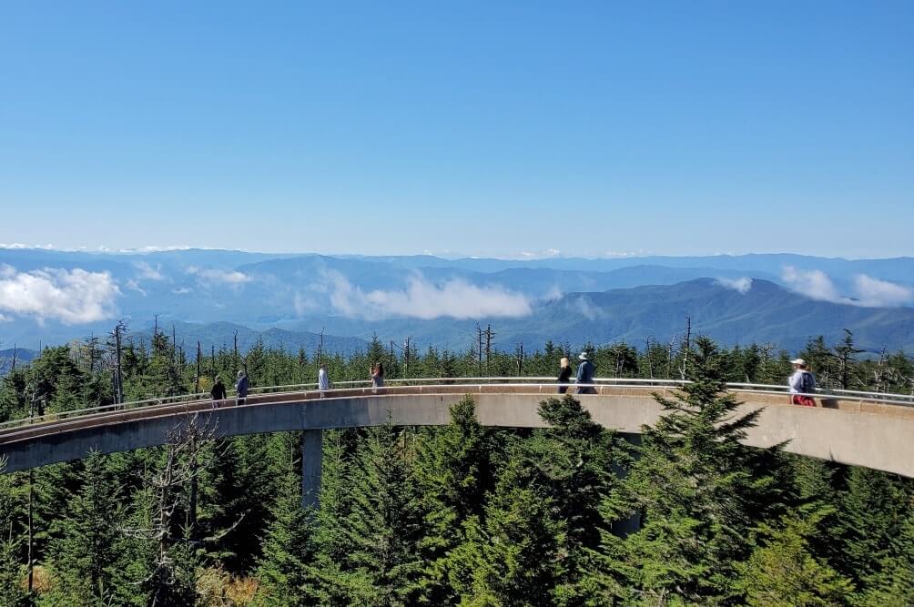
Attempt #3: Beautiful views of the Smoky Mountains from the top of Tennessee!!!
Driving on Newfound Gap Road and further driving up the road to the Clingmans Dome trailhead, it sure LOOKED like a clear day, and it seemed like there would be a GREAT chance for views at the top! Still, this is the Smoky Mountains, and clouds could come rolling in when you least expect it! (Or something like that.)
So while I didn’t run up the trail as I did previously, I tried to be somewhat quick.
And… YAY!!!


And… heading back to the parking lot.


And that’s a bit of what it’s like to hike to the Clingmans Dome tower in good weather and bad weather!
Hikes near Clingmans Dome

Clingmans Dome Trail to Clingmans Dome Tower, 0.5 miles away.
Clingmans Dome Trail to Appalachian Trail, 0.5 miles away.
Clingmans Dome Trail to Mountains-to-Sea Trail, 0.5 miles away.
The Clingmans Dome Trail intersects with the long distance hiking trails (backpacking trails) of the Appalachian Trail (nearly 2,200 miles total from Georgia to Maine) and the Mountains-to-Sea Trail (nearly 1,200 miles total in North Carolina). So if you are hiking these trails in this area, you can also make a side trip to the Clingmans Dome Tower.

But aside from this, if you are a more casual day hiker and you’d like to add another hike to the day you hike to Clingmans Dome, then you have options!
1. Hike to Andrews Bald

This trail starts directly from the Clingmans Dome parking lot. You’ll take the Forney Ridge Trail to get to Andrew’s Bald. This is around a 3.6 mile round trip hike. Take a light picnic lunch and the open field can be the perfect spot to eat with views! Expect far less people compared to the Clingmans Dome Trail. See more about this hike.
2. Hike to Charlie’s Bunion

This trail starts from the Newfound Gap overlook parking lot, which is a 10-15 minute drive from the Clingmans Dome parking lot. This is around 8 miles round trip, and it’s another hike that will give you great views of the Smoky Mountains.
3. Hike the Alum Cave Trail

This trail starts right off of Newfound Gap Road, and it’s around a 20 minute drive from the Clingmans Dome parking lot. If you’re doing a little peak bagging in the Smoky Mountains, this is one to add to the list. Hiking the Alum Cave Trail to the Mt LeConte summit will take you to a peak that is listed as the 3rd highest point in the Smoky Mountains and the 6th highest point in the Appalachian Mountains. Hiking to Mt LeConte is considered to be among THE best day hikes in the Smoky Mountains. While there are many trails that lead to the summit, among the most popular is to take the Alum Cave Trail. This makes it about a 10-11 mile round trip hike. You’ll want to start your day early if you want to hike to both the Clingmans Dome summit and Mt LeConte summit in one day.
If that’s a bit too much hiking for you, another popular option for hiking the same Alum Cave Trail is to “only” go halfway up the Alum Cave Trail where you can see unique geological formations that include the Arch Rock and Alum Cave Bluffs. This would be around a 5.5 mile round trip hike.
See more about the best hikes near Clingmans Dome.
HAPPY HIKING TO THE CLINGMANS DOME OBSERVATION TOWER!
Here are more ideas for a few days in the Smoky Mountains!
More of the best things that the Smoky Mountains is known for is hiking!If you're looking for just one solid day hike in the Smoky Mountains, there's the Mount LeConte hike. Most often this is done as a day hike, but you can also stay overnight near the Mount LeConte summit! There is the LeConte Lodge, which claims to be the highest guest lodge in the eastern part of the United States! (It does book up!)
There are also lots more hikes that come with mountain views. See more about some of the best hikes in the Smoky Mountains.
There are also a lot of hikes to waterfalls. See more about the best waterfall hikes in the Smoky Mountains.
You can also go camping in the mountains. See more about the best campgrounds in Great Smoky Mountain National Park. (No showers in the national park, though!)
Cost to go to Great Smoky Mountains National Park
There is no national park entry fee for Great Smoky Mountains National Park, but as of 2023, there is a parking fee.You'll need a parking pass when you go to the Smoky Mountains.
You can wait until you arrive to buy the parking pass, or you can buy it online before you go at recreation.gov.
Depending on how many days you will be in Great Smoky Mountains National Park, the cost of parking will be $5 or $15 per vehicle.
Plan out your time in the Smoky Mountains!
Some of the best known things in Great Smoky Mountains National Park include Clingmans Dome, Cades Cove, and Roaring Fork Motor Nature Trail!For Clingmans Dome, you can get great views from the parking lot, or you can hike up to the highest point in the Smoky Mountains! (No matter what, you do need weather on your side, though! For me, 3rd time was the charm at Clingmans Dome!) See more about Clingmans Dome.
For Cades Cove, it's all about the slow-going Cades Cove Loop Road! You can drive it, bike it, or walk it! You can make stops to walk inside historic cabins, see a historic mill, and even do a waterfall hike! See more about Cades Cove.
The Roaring Fork Motor Nature Trail is also a slow-going road that you drive and make stops along the way, including quiet stops along a creek or waterfalls hikes. See more about the Roaring Fork Motor Nature Trail.