
Hi there!
Below is basically a Bahia Honda State Park planning map.
Use it to plan your epic Miami to Key West road trip!
See below for the clickable interactive version of the Bahia Honda State Park map! Most icons have pictures, and some have additional info too! If you are on your phone, also see tips for using the map on mobile below the interactive map!
Be sure to play around with the map!
Bahia Honda State Park map (official Florida State Parks map)
If you are looking for the official Bahia Honda State Park map from Florida State Parks: Bahia Honda State Park pdf
If the pdf is not available, find the new one from the official Bahia Honda State Park website and look for “download park map”!

👆 You can find the official Bahia Honda State Park map on the Florida State Parks website. See below for the interactive map with pictures and locations of scenic spots!
If you are looking for a more detailed Bahia Honda State Park campground map, the easiest way might be by using the Florida State Park camping reservation website. Search for any date, and even if there’s no availability, you can click on each of the loops to view the campground map.
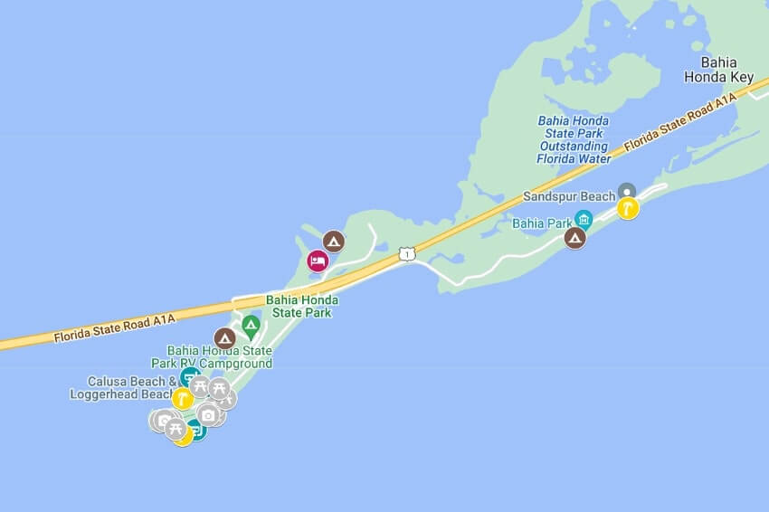
Bahia Honda State Park map (interactive google map)
Click the little icon in the top left corner of the map below to see the list of what you’ll find on this map. This is where you can isolate to find only snorkeling spots, beaches, and campgrounds, for example.
On the map, click on an icon to know what’s there!
Colored icons mean that there’s a link with more information about that spot.
Read about it: Things to do in Bahia Honda State Park
👆 How to start using this map: Click the top left icon! Or just zoom in to start looking and clicking around!
This map may not work very well on this page on mobile, sorry!
In that case, send a link of this page to yourself and try on desktop!
Or…
Tips for using this google map of Bahia Honda State Park on mobile!
If you are on your phone, you can also take a look at this Bahia Honda State Park map. (It is the same map as above but it might be easier for use on your phone.)
For this map, in short, in addition to clicking the icons that you see on the map, also click on the names that come up when you click on an icon!
Most icons have pictures and/or info to go along with it so if you are not seeing it, then click around!
Longer version…
If you do look at the map directly on google, start off by clicking the text at the bottom of the screen (the text that says “bahia honda state park map”) to see the different categories.
Then you can start clicking around on this list.
Or, you can also just start clicking around on the map.
When you click on an icon on the map, you will see the name of the spot come up at the bottom of the screen.
Click on that name.
Then, you will see a picture of that spot (in most cases!) and also possibly more info!
Phones may have different displays but basically click around on both icons and text!
What is on the Bahia Honda State Park map?
- Things to do in Bahia Honda State Park
- Bahia Honda State Park snorkeling spots
- Bahia Honda State Park beaches
- Bahia Honda State Park campgrounds
- Bahia Honda State Park picnic areas
- Bahia Honda State Park scenic spots
- Old Bahia Honda Bridge Trail
More for possibly on your way to Bahia Honda State Park!
- Miami to Key West
- Things to do in the Florida Keys
- Things to do in Everglades National Park
- Everglades National Park alligators
- Everglades National Park crocodiles
- Things to do in Big Cypress National Preserve (alligators!)
- South Pointe Park of Miami Beach
- Oleta River State Park camping cabins (North Miami)
HAPPY BAHIA HONDA STATE PARK TRAVEL PLANNING!
There are partner websites included in this post. I may earn a commission.